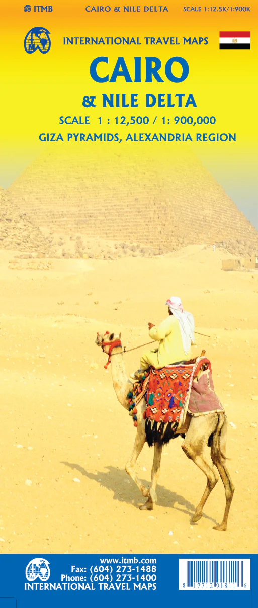
Cairo & The Nile Delta ITMB Map
Double-Sided | Cairo City & Nile Region | Ancient Wonders & Modern Marvels
Unlock the secrets of ancient Egypt and the vibrant energy of modern Cairo with the Cairo & The Nile Delta Map by International Travel Maps (ITMB). This double-sided, full-colour map covers the region in exceptional detail—from the bustling streets of Cairo to the archaeological treasures lining the banks of the Nile. Whether you're planning your next adventure, researching Egypt's geography, or teaching ancient civilizations, this map is both a practical tool and a visual gateway to one of the world’s most storied regions.
🗺️ Map Coverage
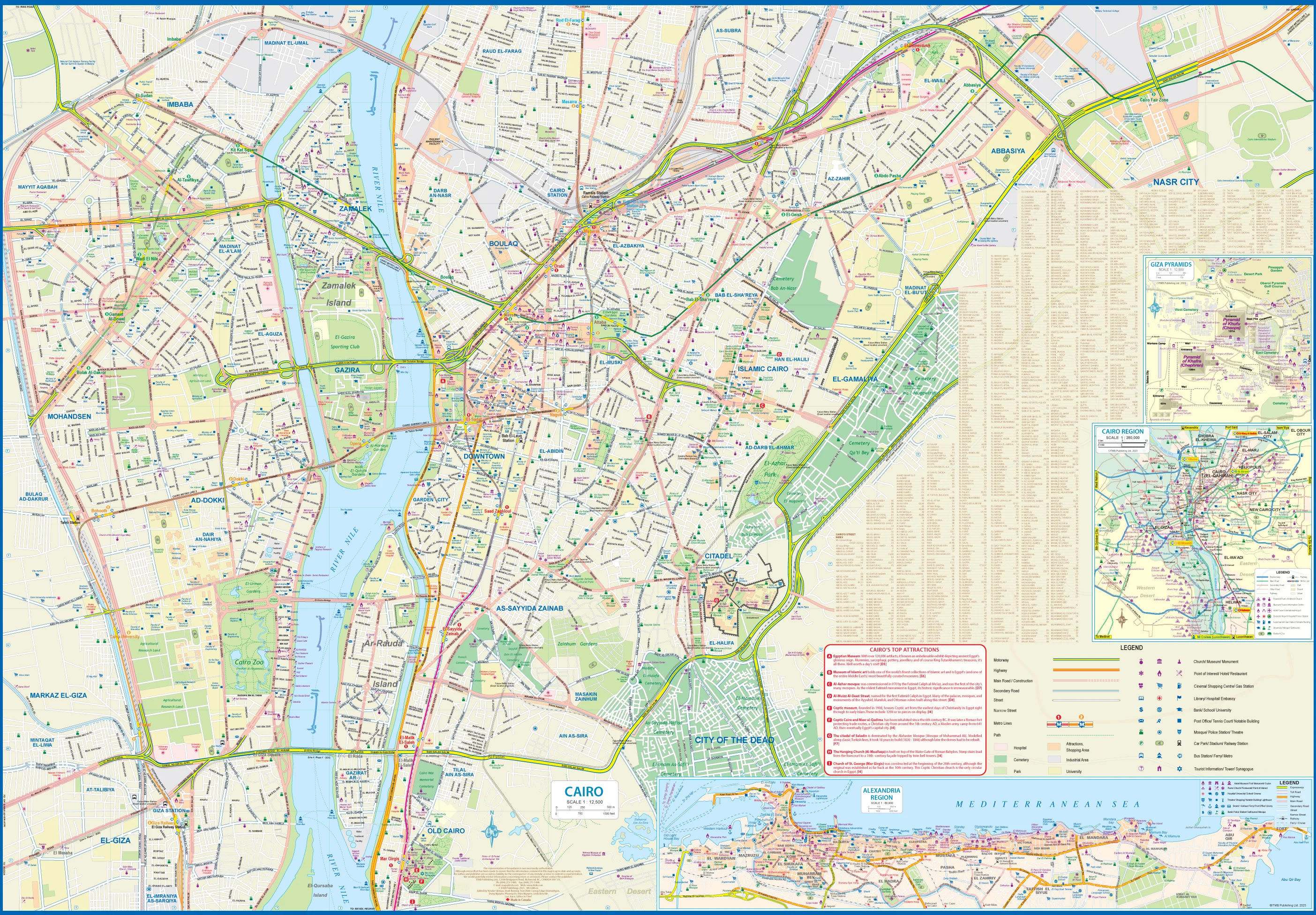
🧭 Side 1: Greater Cairo & Surroundings
This side presents a detailed city map of Cairo, showing:
-
Main streets, landmarks, parks, and districts
-
Expanded Cairo Metro system with recent and proposed lines, including the upcoming extension to Cairo International Airport
-
Inset maps of:
-
Alexandria – the historic port city founded by Alexander the Great
-
Pyramids of Giza – with detailed pyramid layout and access roads
-
Cairo Region Overview – ideal for locating airports and surrounding towns
-
-
🏛️ Tourist highlights: museums, souks, historic mosques, and embassies
-
📍 Top 10 Cairo Attractions list for quick reference
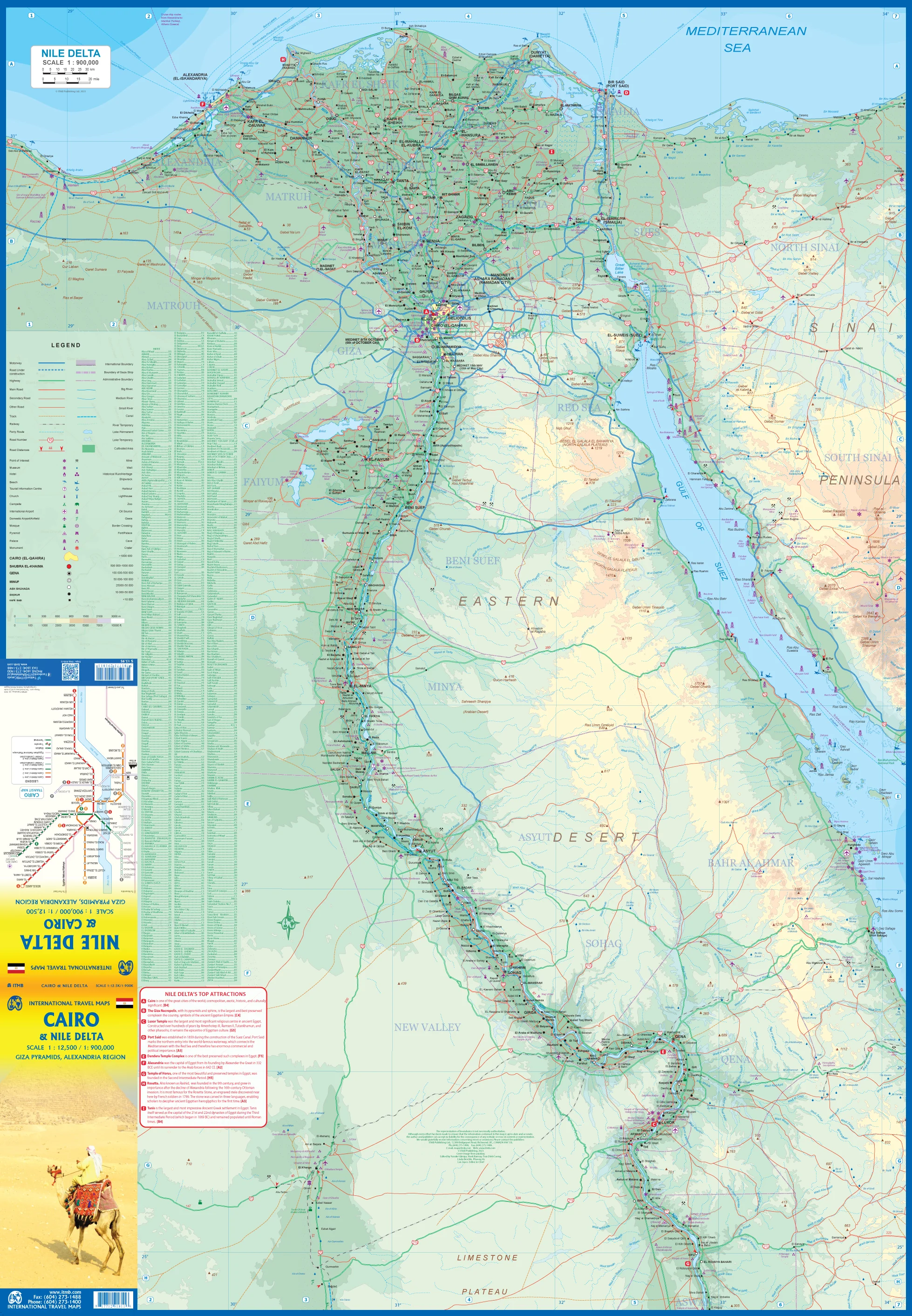
🌅 Side 2: The Nile Delta & River Valley
Follow the course of the Nile River from Cairo south to Luxor, with this broad regional map:
-
The fertile Nile Delta and Upper Nile Valley
-
The Suez Canal, shown in full detail
-
Sections of the Red Sea coastline and Sinai Peninsula
-
Major archaeological sites:
-
Luxor and the Valley of the Kings
-
Temple of Horus at Edfu
-
Dendera, Abydos, and Karnak
-
-
🏺 Top 10 Nile Attractions list for cultural and historical exploration
This side provides essential context for any traveller journeying between Egypt’s modern and ancient worlds.
🎯 Key Features
-
✅ Double-sided for efficient travel and educational use
-
🧭 Accurate and up-to-date road networks and landmarks
-
🏛️ Includes major cultural and archaeological sites
-
🚇 Metro, rail, ferry, and transit connections clearly marked
-
🗂️ Inset maps and regional overviews for quick navigation
-
🌍 Designed for independent travellers, educators, and tour professionals
🧳 Ideal For
-
✈️ Travellers visiting Cairo, Alexandria, Luxor, or cruising the Nile
-
🏺 Cultural enthusiasts and Egyptologists exploring ancient heritage
-
📚 Educators and students studying geography, ancient history, or urban development
-
🧭 Adventurous planners and tour operators needing comprehensive visual tools
🛡️ Optional Lamination Available
Upgrade to a laminated edition for enhanced utility and durability:
-
✍️ Use whiteboard markers to plan, annotate, or teach
-
📌 Apply map dots or flags to highlight routes or locations of interest
-
💧 Water-resistant and tear-proof, perfect for field use or the classroom
-
📜 Flattened and encapsulated in 80-micron gloss laminate for longevity
Note: Slight original fold lines may remain visible under lamination.
📐 Map Specifications
| Feature | Details |
|---|---|
| Edition | Latest available |
| Format | Double-sided (paper or laminated) |
| Scale | Regional and city detail scales |
| Dimensions | 680 mm (w) x 990 mm (h) (approx. 27" x 39") |
| Publisher | International Travel Maps (ITMB) |
| Coverage Area | Cairo, Giza, Alexandria, Suez, Luxor, Nile Valley, Red Sea Coast, Sinai Peninsula |
🌟 Why Choose This Map?
✔️ Comprehensive coverage of Egypt’s most iconic cities and landmarks
✔️ Great for planning trips, classroom learning, or travel display
✔️ Includes practical city navigation + archaeological references
✔️ Ideal for Nile cruises, Cairo city breaks, and Red Sea excursions
✔️ High-quality print or laminated options for every type of user
If you're exploring the wonders of Egypt or want to gift someone a useful and beautiful travel reference, this map is a brilliant companion. Pair it with our Egypt Country Map or Middle East regional titles for a complete set.
🛒 Add it to your cart today and start your journey through time and terrain.
Description
Double-Sided | Cairo City & Nile Region | Ancient Wonders & Modern Marvels
Unlock the secrets of ancient Egypt and the vibrant energy of modern Cairo with the Cairo & The Nile Delta Map by International Travel Maps (ITMB). This double-sided, full-colour map covers the region in exceptional detail—from the bustling streets of Cairo to the archaeological treasures lining the banks of the Nile. Whether you're planning your next adventure, researching Egypt's geography, or teaching ancient civilizations, this map is both a practical tool and a visual gateway to one of the world’s most storied regions.
🗺️ Map Coverage
🧭 Side 1: Greater Cairo & Surroundings
This side presents a detailed city map of Cairo, showing:
-
Main streets, landmarks, parks, and districts
-
Expanded Cairo Metro system with recent and proposed lines, including the upcoming extension to Cairo International Airport
-
Inset maps of:
-
Alexandria – the historic port city founded by Alexander the Great
-
Pyramids of Giza – with detailed pyramid layout and access roads
-
Cairo Region Overview – ideal for locating airports and surrounding towns
-
-
🏛️ Tourist highlights: museums, souks, historic mosques, and embassies
-
📍 Top 10 Cairo Attractions list for quick reference
🌅 Side 2: The Nile Delta & River Valley
Follow the course of the Nile River from Cairo south to Luxor, with this broad regional map:
-
The fertile Nile Delta and Upper Nile Valley
-
The Suez Canal, shown in full detail
-
Sections of the Red Sea coastline and Sinai Peninsula
-
Major archaeological sites:
-
Luxor and the Valley of the Kings
-
Temple of Horus at Edfu
-
Dendera, Abydos, and Karnak
-
-
🏺 Top 10 Nile Attractions list for cultural and historical exploration
This side provides essential context for any traveller journeying between Egypt’s modern and ancient worlds.
🎯 Key Features
-
✅ Double-sided for efficient travel and educational use
-
🧭 Accurate and up-to-date road networks and landmarks
-
🏛️ Includes major cultural and archaeological sites
-
🚇 Metro, rail, ferry, and transit connections clearly marked
-
🗂️ Inset maps and regional overviews for quick navigation
-
🌍 Designed for independent travellers, educators, and tour professionals
🧳 Ideal For
-
✈️ Travellers visiting Cairo, Alexandria, Luxor, or cruising the Nile
-
🏺 Cultural enthusiasts and Egyptologists exploring ancient heritage
-
📚 Educators and students studying geography, ancient history, or urban development
-
🧭 Adventurous planners and tour operators needing comprehensive visual tools
🛡️ Optional Lamination Available
Upgrade to a laminated edition for enhanced utility and durability:
-
✍️ Use whiteboard markers to plan, annotate, or teach
-
📌 Apply map dots or flags to highlight routes or locations of interest
-
💧 Water-resistant and tear-proof, perfect for field use or the classroom
-
📜 Flattened and encapsulated in 80-micron gloss laminate for longevity
Note: Slight original fold lines may remain visible under lamination.
📐 Map Specifications
| Feature | Details |
|---|---|
| Edition | Latest available |
| Format | Double-sided (paper or laminated) |
| Scale | Regional and city detail scales |
| Dimensions | 680 mm (w) x 990 mm (h) (approx. 27" x 39") |
| Publisher | International Travel Maps (ITMB) |
| Coverage Area | Cairo, Giza, Alexandria, Suez, Luxor, Nile Valley, Red Sea Coast, Sinai Peninsula |
🌟 Why Choose This Map?
✔️ Comprehensive coverage of Egypt’s most iconic cities and landmarks
✔️ Great for planning trips, classroom learning, or travel display
✔️ Includes practical city navigation + archaeological references
✔️ Ideal for Nile cruises, Cairo city breaks, and Red Sea excursions
✔️ High-quality print or laminated options for every type of user
If you're exploring the wonders of Egypt or want to gift someone a useful and beautiful travel reference, this map is a brilliant companion. Pair it with our Egypt Country Map or Middle East regional titles for a complete set.
🛒 Add it to your cart today and start your journey through time and terrain.